A landscape that looks still but is always moving
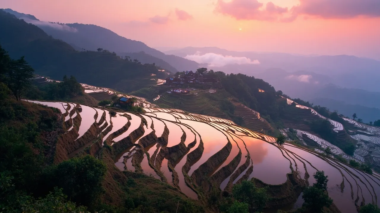
From a high viewpoint in Honghe Hani and Yi Autonomous Prefecture, the rice terraces can look like enormous steps cut into the mountains. In the right light, each flooded field catches the sky. One terrace reflects silver; another turns green with rice; a third holds the shadow of a cloud. Photographs make the scene seem quiet and complete, as if the mountains simply arrived in this shape.
They did not. The Hani rice terraces are a working landscape maintained through labor, custom, water management, and long memory. Their history is commonly described as reaching back about 1,300 years. Generations of Hani communities adapted steep slopes for rice while preserving forests above villages and guiding water through channels, springs, and small streams.
The most useful way to understand the system is through four connected elements: forest, village, terraces, and water. Remove one and the others become harder to sustain. Forests help hold moisture and release water gradually. Villages organize homes, labor, ritual, and daily decisions. Terraces grow rice while slowing runoff and preventing soil from simply racing downhill. Water links the whole arrangement.
This is why the Honghe Hani Rice Terraces were inscribed on the UNESCO World Heritage List in 2013 as a cultural landscape. The designation recognizes a relationship between people and mountains, not a natural view untouched by human hands. The terraces are beautiful because they are cultivated, and they remain useful because beauty was never their only purpose.
The four-part system: forest, village, terrace, water
Start at the top. Forested mountain areas capture rain and help regulate the flow that later reaches fields and homes. In a steep monsoon environment, water arriving all at once can destroy soil and walls. Vegetation slows it. Roots hold the ground. Springs and small channels then carry water downward in a less destructive rhythm.
Villages sit between the forest and the terraces. Their location is not accidental. People need access to water, farmland, paths, and fuel, while the settlement itself has to remain protected from unstable slopes. Hani houses, often built with local materials and adapted to the climate, form part of the social infrastructure. A village is a place to live, but also a place where irrigation, planting, harvest, maintenance, and ritual obligations are discussed.
Below the village, terraces follow the contours of the mountain. Their walls are repaired by hand and their fields can be surprisingly small. The stepped arrangement reduces the speed of water and allows rice cultivation where flat land is scarce. Farmers can manage planting at different elevations and keep the productive surface from washing away.
Water is the element visitors notice last, even though it makes the scene possible. Channels distribute spring water, and the flooded plots pass it from one level to another. Ducks, fish, insects, and plants may share the fields, creating a small agricultural ecology rather than a single crop in isolation. The system is not perfectly uniform, and local practices differ, but the four elements provide a strong starting map.
Think of the terraces less as a staircase and more as a conversation. Rain, trees, soil, stone, rice, animals, and people answer one another every day.
A 1,300-year history shaped by Hani knowledge
The Hani are one of China’s officially recognized ethnic minority groups, with communities concentrated in Yunnan and related populations across the border in Southeast Asia. Their mountain agriculture developed through movement, adaptation, and close reading of local conditions. A terrace wall that works on one slope may need a different design on another. A water route that serves one village may be governed differently in the next.
A precise origin date for every terrace is impossible. The 1,300-year figure offers a broad historical frame for the development of the Honghe system, not a claim that all visible fields were built at the same moment. Landscapes accumulate. Older paths are changed, walls are rebuilt, channels are extended, and fields may be abandoned or restored as communities respond to labor and environmental pressures.
Hani knowledge is practical and social at the same time. Farmers know when water is likely to arrive, where a wall is vulnerable, how a slope behaves after heavy rain, and which tasks must be coordinated. Customs and local rules can help distribute responsibility. Ritual life gives the agricultural calendar meaning, marking relationships among people, ancestors, forests, water sources, and the land.
This combination is easy to underestimate from outside. Modern visitors may see a spectacular panorama and assume the technique is simply “ancient engineering.” Engineering is part of the story, but so are negotiations, inherited habits, and daily repair. The terrace system is not a machine that runs without people. It is a social arrangement that happens to be visible in earth and water.
The landscape has also changed over time. Roads, schools, tourism, new crops, migration, and changing economic expectations all affect village life. Preserving the terraces therefore cannot mean demanding that Hani communities remain frozen in a romantic past. It means supporting the conditions under which residents can continue to make informed choices about the landscape.
What UNESCO recognized in 2013
UNESCO inscription in 2013 placed the Honghe Hani Rice Terraces among the world’s notable cultural landscapes. The designation recognizes the interaction of environmental knowledge, agricultural production, social organization, and cultural practices. It also brings obligations: conservation planning, management, documentation, and efforts to balance tourism with the needs of residents.
World Heritage status can be helpful. It may bring funding for research and infrastructure, strengthen public awareness, and encourage local and national institutions to coordinate. It gives international travelers a reason to learn about Honghe before arriving. It can also help protect the idea that a terrace is more than a scenic photograph.
But a UNESCO label does not solve every problem. Tourism can increase pressure on roads, water, waste systems, and housing. Visitors may prefer the most famous viewpoints, creating crowded spots while less visible villages receive little benefit. A demand for constant green terraces can clash with agricultural calendars. If every field is treated as a stage set, farmers may be asked to prioritize the image over the crop.
Responsible interpretation starts by using the official name and learning what it describes: a large cultural landscape with many communities and varied conditions, not one postcard location. Responsible travel also means staying on marked paths, asking before entering homes or fields, and paying for local guides or services when possible.
The best heritage programs make residents partners rather than scenery. Hani communities hold knowledge that outside experts cannot replace. Conservation plans should listen to farmers, women managing household and field work, elders who remember water routes, and young people deciding whether they can build a future locally.
Recognition is most meaningful when it supports lived continuity, not just international prestige.
Seasons, reflections, and the work behind the view
The terraces change character through the year. In winter and early spring, many plots are flooded and unplanted, creating the famous mirror-like reflections. The lines of the fields become especially clear, and sunrise can turn the water pink, gold, or gray. Later, young rice gives the slopes a soft green surface. As the crop matures, the color deepens and the texture becomes fuller. Harvest brings warm tones and a different rhythm of movement.
Weather matters as much as the calendar. Mist can hide entire villages and then lift in a few minutes. Rain may make paths slippery but reveal the system’s purpose as water runs through channels and over terrace edges. Dry periods can change which plots are flooded and how farmers allocate water. No single month provides the “real” terrace view.
Photographers should remember that a striking image depends on ordinary labor. The wall under the reflection may have been repaired by hand. The water may be traveling through a channel cleared before dawn. A field may look empty because a family is preparing soil. Do not step into a plot for a better angle, and do not block narrow paths during planting or harvest.
Early mornings are popular at viewpoints such as Duoyishu, but quieter experiences can be found by walking with a local guide away from the main platform. Ask what is being planted, where the water comes from, and how the village shares maintenance. A conversation can turn a beautiful view into an intelligible place.
Bring layers and shoes with real grip. Mountain weather shifts quickly, and paths can be damp even under a clear sky. Keep camera gear protected from mist and rain. The landscape rewards patience: light changes slowly, then suddenly, and the best moment may arrive after the first photograph has already been taken.
Food, biodiversity, and everyday life
Rice is the center of the terraces, but the fields support more than rice. In traditional wet cultivation, fish and ducks may occupy the same water as the crop, while frogs, insects, and plants contribute to a wider food web. Forests above the farms hold birds and other wildlife, and the movement of water connects habitats that a map might separate.
The agricultural system’s value is therefore both cultural and ecological. A forest kept for water protection is also habitat. A terrace wall built for cultivation can reduce erosion. A channel that serves irrigation may shape the location of a path or the timing of village work. These benefits overlap; they are not neatly divided into “nature” and “culture.”
Food offers a direct way to understand the landscape. Local rice varieties, fermented foods, vegetables, poultry, and other ingredients reflect elevation, climate, and household practice. What appears on a village table may tell you as much about the terrace system as the panorama does. If you visit a family-run guesthouse, ask how meals are sourced and whether there are seasonal specialties.
Do not assume every Hani community has identical customs or architecture. Regional differences matter, and ethnic identity is not a tourist performance that can be summarized by one costume or one dish. Listen to local explanations. A guide may point out a water source, a sacred forest, or a village practice that is invisible in a wide-angle photograph.
The future of the terraces will depend partly on whether farming remains economically and socially viable. Young people may seek education and jobs elsewhere; older farmers may face labor shortages. Tourism can provide income, but only if benefits reach communities and do not increase the cost of living beyond what local households can manage.
The rice terraces are a landscape of food first, scenery second. Keeping that order in mind is a form of respect.
Visiting Honghe with attention rather than a checklist
Honghe is a large region, and travel times between viewpoints can be longer than a map suggests. Build flexibility into your schedule. Roads wind through mountains, and rain can affect conditions. A local guide can make the trip safer and more informative, especially if you want to walk through villages or understand water management.
Stay in licensed guesthouses when possible and ask about village rules. Some areas charge entrance or maintenance fees; pay them rather than trying to avoid the system. Dress practically and modestly, especially when visiting homes, village religious spaces, or community events. Photography is not automatically permission. Ask before photographing people, ceremonies, or private courtyards.
Treat water channels and terrace walls as infrastructure, not decorations. Do not wash objects in irrigation water, climb on fragile walls, or enter planted fields. Carry out rubbish and reduce disposable packaging. Drones may be restricted or unwelcome; check local regulations and never fly over homes or ceremonies without explicit permission.
Before going, learn a little about Hani history and the UNESCO landscape. That preparation changes the experience. Instead of hunting for the one perfect reflection, you begin to notice the forest above the village, the channel beside a path, and the farmer checking a wall. The view becomes a system.
The Honghe terraces have lasted for centuries because people kept working with water, slope, and season. Their future will not be secured by admiration alone. It will be secured when conservation supports livelihoods, when tourism behaves responsibly, and when Hani communities remain able to decide how their mountain home should develop.